


The BC Wildfire Service says the area restriction around the Weasel Creek wildfire is being reduced in size.
While the size of the restricted area has been reduced, residents are advised there is still a continued need to protect the public where ongoing fire suppression activities are taking place.
The area restriction will remain in effect until October 15th or until rescinded.
This area remains an active worksite and with a camp in place up the Flathead Valley, there will be an increase in traffic along the Forest Service Roads outside of the restricted area.
A map of the new restricted area is available here.
A press release from the BC Wildfire Service can be found below.
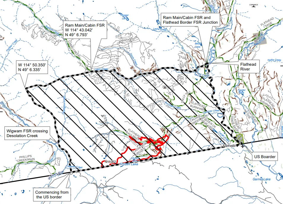
The BC Wildfire Service continues to respond to the Weasel Creek wildfire (N11062) that originated two kilometres west of Frozen Lake and 39 kilometres southeast of Baynes Lake, on the United States side of the border.
Effective immediately the area restriction in the Weasel Creek wildfire area will be reduced in size. While the size has been reduced, there is still a continued need to protect the public in areas where ongoing fire suppression activities are taking place.
This reduced area restriction is now in effect and will remain in effect until 12:00 noon (PDT) on October 15, 2022, or until rescinded. The order applies to Crown land within the geographic boundaries described below and outlined in the correlated map:
Commencing from the US border due north to southern end of Wigwam Creek FSR. Following Wigwam FSR north to crossing with Desolation Creek, follow the height of land North North-West from crossing to W 114° 50.350′ / N 49° 6.335′. East to the Ram Main/Cabin FSR roughly 25 km past junction of Wigwam River FSR and Ram Creek FSR (at approximately 69 km maker – W 114° 43.042′ / N 49° 6.793′).
Following Ram Main/Cabin FSR Eastward to the junction with Flathead Border FSR (77km on Flathead Border FSR), then directly East to Flathead River, continuing South down Flathead River to US border. NOTE: Travel on the Wigwam Creek FSR and Ram Main/Cabin FSR is not permitted.
A map of the affected area is available here: http://ow.ly/i2nL50KqJKV
Under this Order and section 11(2) of the Wildfire Act, a person must not remain in or enter the restricted area, unless the person:
1.) first receives written authorization of an official designated for the purposes of the Wildfire Act, or
2.) enters the area only in the course of:
(a) travelling to or from his or her residence, that is not under an evacuation order;
(b) using a highway as defined in the Transportation Act;
(c) travelling as a person acting in an official capacity as defined in s.56 of the Wildfire Act; or
(d) travelling for the purpose of supporting wildfire suppression or enforcement patrol activities.
Failure to comply with Section 11 restricted area requirements may result in a violation ticket of $1,150.
This area remains an active worksite and with a camp in place up the Flathead Valley there will be an increase in traffic along the Forest Service Roads outside of the restricted area. This includes large, slow moving transport trucks providing services for this camp.
Reminder that in order to safely travel on resource roads (ie. Forest Service Roads), there are rules that must be followed. Resource roads are not built to the same standards as highways. Ground crews will be continuing to use resource roads in the area for suppression activity and users must exercise caution. To review the resource road user safety guide click here.
Road closures and area restrictions are subject to change depending on fire activity. For the most current information please visit the bans and restrictions section of the BC Wildfire website for the Southeast Fire Centre click here.
– With files from the BC Wildfire Service.


Comments