


An Area Restriction Order has been issued around the Mia Creek Wildfire which is located about 15 km east of Fairmont Hot Springs.
The out of control fire was discovered July 24, it has grown to 2,301 hectares.
The Area Restriction Order covers:
- Commencing at the junction of Kootenay River FSR (9km Mark) & Kootenay-Bypass FSR (0km Mark) @ [50° 12.032′, -115° 43.321′];
- Going SOUTHEAST along Kootenay-Bypass FSR to junction of Kootenay-Bypass FSR (10km Mark) & Whiteswan Lake FSR (10km Mark) @ [50° 8.207′, -115° 39.446′];
- Going EAST along Whiteswan Lake FSR to the junction of Whiteswan Lake FSR (32.5km Mark) & White Rock FSR @ [50° 9.684′, -115° 25.659′];
- Going NORTHWEST along White Rock FSR to the junction of White Rock FSR & Kootenay River FSR @ [50° 22.837′, -115° 36.831′];
- Going SOUTH along Kootenay River FSR to Point of Commencement
-
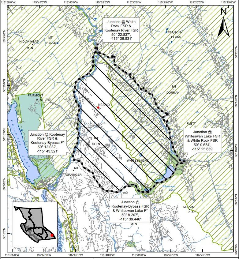
- Area Restriction Order around Mia Creek Wildfire
An Area Restriction Order is meant to keep the public away from active firefighting areas and to ensure access for BC Wildfire Service crews.
Find more information from the BC Wildfire Service below:
The BC Wildfire Service has implemented an Area Restriction Order for the vicinity of the Mia Creek wildfire (N22240), which originated approximately 15 kilometres east of Fairmont. This area restriction reflects the need to protect the public in areas where fire suppression activities are taking place.
This restriction is currently in effect and will remain in effect until 12:00 noon (PDT) on October 15, 2023, or until rescinded. The order applies to Crown land within the geographic boundaries described below and outlined in the provided map.
Area Restriction Order details:
- Commencing at the junction of Kootenay River FSR (9km Mark) & Kootenay-Bypass FSR (0km Mark) @ [50° 12.032′, -115° 43.321′];
- Going SOUTHEAST along Kootenay-Bypass FSR to junction of Kootenay-Bypass FSR (10km Mark) & Whiteswan Lake FSR (10km Mark) @ [50° 8.207′, -115° 39.446′];
- Going EAST along Whiteswan Lake FSR to the junction of Whiteswan Lake FSR (32.5km Mark) & White Rock FSR @ [50° 9.684′, -115° 25.659′];
- Going NORTHWEST along White Rock FSR to the junction of White Rock FSR & Kootenay River FSR @ [50° 22.837′, -115° 36.831′];
- Going SOUTH along Kootenay River FSR to Point of Commencement
Note: Travel is permitted along the road from the junction of the Kootenay River FSR (9km Mark) & Kootenay-Bypass FSR (0km Mark); SOUTHEAST to the junction of Whiteswan Lake FSR (32.5km Mark) & White Rock FSR. Entry into the restricted area from this travel corridor is prohibited.
For a map of the affected area click here.
Under this Order and section 11(2) of the Wildfire Act, a person must not remain in or enter the restricted area without the prior written authorization of an official designated for the purposes of the Wildfire Act, unless the person:
1) First receives written authorization of an official designated for the purposes of the
Wildfire Act, or
2) Enters the area only in the course of:
- travelling to or from his or her principle residence that is not under an evacuation order;
- using a highway as defined in the Transportation Act;
- travelling as a person acting in an official capacity as defined in s.56 of the Wildfire Act; or
- travelling for the purpose of supporting wildfire suppression or enforcement patrol activities.
The BC Wildfire Service reminds the public that although access to a private residence is permitted, the public must stay out of active fire areas. Public interference has a direct impact on the effectiveness of fire suppression activities and poses safety risks to both the public and responders who are working to contain the fire.
– Article includes information from BC Wildfire Service


Comments