


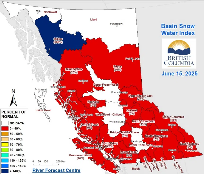
Source: BC River Forecast Centre
Final snowpack figures of the season are pointing to a dry summer in the Kootenays this year.
The BC River Forecast Centre has released its June 15 snow bulletin today (Jun. 19), and measurements show that the East Kootenay region is currently at 0 per cent of its normal levels, down 74 per cent from the same time last year.
“The first province-wide sustained high-pressure ridge impacted the province during the first week of June, bringing dry and seasonally warm temperatures,” wrote the forecaster. “Most areas of B.C. recorded the warmest temperatures of the year, so far, and rapidly melted the remaining high elevation snow.”
Upper Columbia’s snowpack is at 30 per cent of normal, while West Kootenay sits at 9 per cent. Overall, the provincial snowpack is averaging 13 per cent of normal levels, which points to “elevated drought hazards” in the coming months.
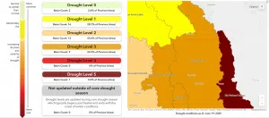
Source: B.C. Drought Information Portal
B.C.’s Drought Information Portal shows the southeast in increasingly worse drought due to the continued lack of rain.
The latest update indicates that the Elk-Flathead Valleys basin, where Fernie is located, is currently at Level 5 – the most severe drought conditions. The Kootenay River area, which includes cities like Cranbrook and Kimberley, is currently at Level 3. That level indicates likely impacts to residents and the ecosystem.
Rainfall is expected for much of the province this week, with the heaviest amounts in the northeast and southeast.
You can find more details from the BC River Forecast Centre here.


Comments